
Friday, September 30, 2011
Day 11 - (Detour) Williams, AZ to Las Vegas, NV
Sorry, but as the saying goes, what happens in Vegas, stays in Vegas.

Thursday, September 29, 2011
Day 10 - Flagstaff, AZ to Williams, AZ
No trip across the US would be complete without a trip to one of the major National Parks, and thus today we drove the short leg of 66 to Williams, before breaking off to see the largest hole in the ground Arizona has to offer, the Grand Canyon.
But first, heading out of Flagstaff we detoured to see yet another 'Muffler Man', a lumberjack this time, once stationed outside Granny's Closet where we ate last night, and now the mascot for Northern Arizona University.

Our drive to Williams was fairly uneventful, the pine forests making a refreshing change from the plains of the last couple of days, and they stayed with us all the way to the Grand Canyon. And what is there to say about it that wouldn't be an understatement? Most people have seen pictures of it, and like ours they don't really do it justice. Simply, if you've already been, you know what we're talking about, and if you haven't then we hope our photo's inspire you to visit.


We stayed to watch the sunset, which was fabulous, and it's so dark round here there were far more stars visible than we're used to in Chicago. Even though we're arrivng in the dark and missing some of Williams, this made it worth while...


There is a train to the Grand Canyon, and anyone who knows us will be surprised we didn't take it, but it was rather expensive and we heard somewhat gimmicky - cowboys etc 'entertaining' you the whole way, and the train being 'held up' on the way back. So we decided against it, and we were glad as we would have missed out on the sunset, and you get quite used to being able to set your own schedule. However, don't despair, we are making up for it, we're sleeping in a rail car this evening - photo's tomorrow.
But first, heading out of Flagstaff we detoured to see yet another 'Muffler Man', a lumberjack this time, once stationed outside Granny's Closet where we ate last night, and now the mascot for Northern Arizona University.

Our drive to Williams was fairly uneventful, the pine forests making a refreshing change from the plains of the last couple of days, and they stayed with us all the way to the Grand Canyon. And what is there to say about it that wouldn't be an understatement? Most people have seen pictures of it, and like ours they don't really do it justice. Simply, if you've already been, you know what we're talking about, and if you haven't then we hope our photo's inspire you to visit.


A little intrepid off-roading at the Canyon edge


The Colorado River winding through the bottom of the canyon
We stayed to watch the sunset, which was fabulous, and it's so dark round here there were far more stars visible than we're used to in Chicago. Even though we're arrivng in the dark and missing some of Williams, this made it worth while...


A quite magical sunset
There is a train to the Grand Canyon, and anyone who knows us will be surprised we didn't take it, but it was rather expensive and we heard somewhat gimmicky - cowboys etc 'entertaining' you the whole way, and the train being 'held up' on the way back. So we decided against it, and we were glad as we would have missed out on the sunset, and you get quite used to being able to set your own schedule. However, don't despair, we are making up for it, we're sleeping in a rail car this evening - photo's tomorrow.
Wednesday, September 28, 2011
Day 9 - Gallup, NM to Flagstaff, AZ
Just in case you were starting to think things were getting rather serious, we got things going in true 66 spirit by galloping through Gallup, pausing by another famed Route 66 "muffler man" giant, the cowboy brother to the others we have seen.

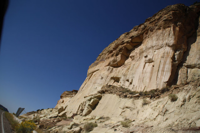
Again, much of the route in these parts requires some interstate driving, but we were able to break away from I-40 as we approached the Arizona state line. Although the terrain was very similar to what we've previously seen, this time Route 66 hugged the cliffs and we had some good views of the mesa valleys, with the interstate and railroad below us.


And with very little aplomb we crossed into Arizona, state number seven, Route 66 time zone number 3 (well, 2 1/2 I guess, since Arizona doesn't follow daylight savings time), and we only just managed to see the state line.

We had a day full of natural wonders, and our time in Arizona seems as if it's mainly going to focus on large holes in the ground. But interesting holes, none the less. First up, the Petrified Forest National Park, of which the Painted Desert forms a part.
The desert is truly spectacular; a scene of mesas and hills spread beneath your feet, and made up of a spectrum of colours, which seems to appear from nowhere as you crest the top of a ridge. Though the ever-present Interstate is still just audible, otherwise all you can hear are insects and birds. The park rangers said that the 28 mile drive through the park takes 45 minutes with no stops, we were there for at least 3 hours (and I have the sun burn to prove it). The other attraction of the park is of course, the petrified wood, which was also incredible. We hope the following will inspire you to come here one day.


We stopped for lunch at Joe and Aggie's Cafe in Holbrook, an original Route 66 business which was actually visited by the producer of the Pixar movie "Cars", and provided part of the inspiration for places in Radiator Springs in the film. The cafe is mentioned in the credits!


Another road sign destination to tease the traveller is that for Meteor Crater, we debated stopping as it was nearing the end of the day, but decided to go in end and just snuck in before it closed.


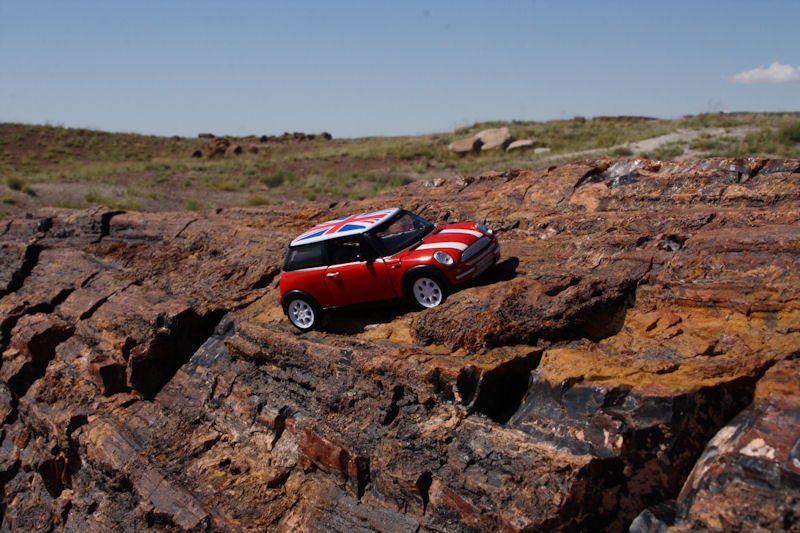
OK, ok, so it's not full scale. It's the mini Mini sitting on a 6ft long petrified log. (It was placed very carefully so as to not damage the rock, of course).
Back to the silly Route 66 attractions: the Wigwam Motel in Holbrook is one of two remaining of these 1950's era motels. There were over half a dozen stretching across Route 66 back in the day. Apparently the rooms are bigger on the inside than they look.


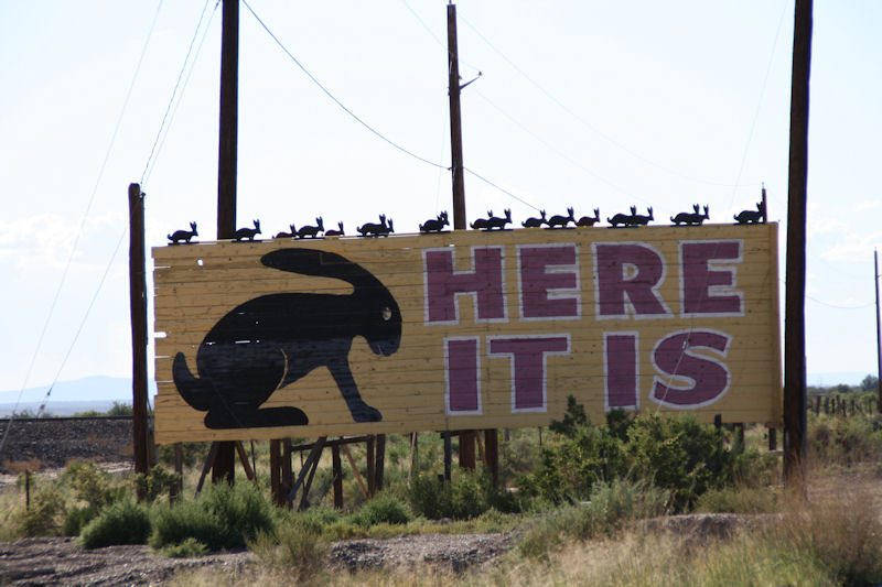
Here it is - there were once hundreds of billboards all across America advertising the Jackrabbit Trading Post (in guess where? The town of Jackrabbit of course, haven't you worked this out yet), and they all lead to here. The saying went that you hadn't been to the Southwest until you had been to the Jackrabbit. The billboards are nearly all gone now, but the famous 'Here it is' board announcing your eventual arrival in Jackrabbit still remains. And it wouldn't be Route 66 without an over sized jackrabbit to ride on, would it?.


Although Route 66 is littered with old derelict gas stations, the "Two Arrows" station and trading post, now long shuttered, is one of the few that stand out as a must see icon of the road. Hopefully one day these arrows will find a better home.

And here's a non-Route 66 quirk. Along I-40, exit signs were consistently in pairs, only a few feet apart, with the first completely obscuring the second (luckily, they had the exact same info). What's going on with that - government bureaucracy gone awry?

The approach to Flagstaff, into the setting sun with the mountains for backdrop. Arizona has been outdoing itself scenery-wise so far.


He now works as a car salesman
Again, much of the route in these parts requires some interstate driving, but we were able to break away from I-40 as we approached the Arizona state line. Although the terrain was very similar to what we've previously seen, this time Route 66 hugged the cliffs and we had some good views of the mesa valleys, with the interstate and railroad below us.


At 80degF and climbing, we basically decided to ignored this sign

This sign on the other hand deserved more attention

This is known as Devil's Cliff


We had a day full of natural wonders, and our time in Arizona seems as if it's mainly going to focus on large holes in the ground. But interesting holes, none the less. First up, the Petrified Forest National Park, of which the Painted Desert forms a part.
The desert is truly spectacular; a scene of mesas and hills spread beneath your feet, and made up of a spectrum of colours, which seems to appear from nowhere as you crest the top of a ridge. Though the ever-present Interstate is still just audible, otherwise all you can hear are insects and birds. The park rangers said that the 28 mile drive through the park takes 45 minutes with no stops, we were there for at least 3 hours (and I have the sun burn to prove it). The other attraction of the park is of course, the petrified wood, which was also incredible. We hope the following will inspire you to come here one day.


This and the next photo are of petroglyphs, actual hand carvings by Native Americans done hundreds and hundreds of years ago, and survive to this day, despite being exposed to the elements.


Petrified wood from trees which lived millions of years ago.


This petrified log has had the rock below it eroded away over time, forming a natural bridge. Although it supported itself, continued erosion threatened to cause it to collapse, hence the concrete beam underneath, which was put in place in 1917.

We stopped for lunch at Joe and Aggie's Cafe in Holbrook, an original Route 66 business which was actually visited by the producer of the Pixar movie "Cars", and provided part of the inspiration for places in Radiator Springs in the film. The cafe is mentioned in the credits!


The wall on the cafe provides a handy map to see our progress between Lake Michigan and the Pacific Ocean
Another road sign destination to tease the traveller is that for Meteor Crater, we debated stopping as it was nearing the end of the day, but decided to go in end and just snuck in before it closed.

The approach up to the crater rim

It's about 3/4 of a mile wide. The photo's don't quite do justice to the scale of the hole in the ground.

The meteor which created it was about 150 yards wide, but only small traces of the meteor still exist buried in the ground.

In fact, the fact that it was formed by a meteor impact at all, as opposed to a volcano, wasn't settled completely until the 1960s by local meteorologists (no wait, that's not right, what is a meteor person called?)
The Arizona topography also provided an opportunity to take the Mini off-road a bit. All things considered, I think it did quite well.
Are you sure this is the marked trail on the map?!
OK, ok, so it's not full scale. It's the mini Mini sitting on a 6ft long petrified log. (It was placed very carefully so as to not damage the rock, of course).
Back to the silly Route 66 attractions: the Wigwam Motel in Holbrook is one of two remaining of these 1950's era motels. There were over half a dozen stretching across Route 66 back in the day. Apparently the rooms are bigger on the inside than they look.


Although Route 66 is littered with old derelict gas stations, the "Two Arrows" station and trading post, now long shuttered, is one of the few that stand out as a must see icon of the road. Hopefully one day these arrows will find a better home.

And here's a non-Route 66 quirk. Along I-40, exit signs were consistently in pairs, only a few feet apart, with the first completely obscuring the second (luckily, they had the exact same info). What's going on with that - government bureaucracy gone awry?

The approach to Flagstaff, into the setting sun with the mountains for backdrop. Arizona has been outdoing itself scenery-wise so far.


Tuesday, September 27, 2011
World's Largest x2

World's largest petrified tree, called "Geronimo", at an I-40 Indian trading post of the same name.

World's largest map of Route 66, at another trading post near Meteor City.
Day 8 - Santa Fe, NM to Gallup, NM
First off, a quick update on our dinner last night. We went to a restaurant called Cowgirl BBQ on the recommendation of the lady at the front desk of our hotel.
The food was great, but the live music was fabulous. Not country & western, as you might expect, but a band called Welcome to Bohemia playing music which was more like polka, French and Eastern European. They were a big hit with the crowd, us inlcuded.

On to day 8 though. Big News of the morning though - Neil shaved for the first time this trip. We grabbed breakfast at a small creperie attached to our hotel. Again, not what you necessarily expect in Santa Fe, but delicious. After breakfast we did stroll across the street to a very nice looking hat shop; they actually custom make all their hats on site, and even had a fitting chair.

We drove south from Santa Fe (after stopping to snap our third state capitol) and started descending again through the mountains towards Albuquerque to rejoin the later alignment of the route. Albuquerque is a decent sized city, the largest in the state, but still retains some old Route 66 attractions.


The diner was like a step back in time to the 1950's. The waitresses were resplendent in turquoise dresses, a juke box played Elvis and Jerry Lee Lewis, and the walls were filled with Route 66 memorabilia and period advertisements.


Leaving the city to the west, we started climbing again up and over Nine Mile Hill. As with the previous couple of days, we had to drive along the interstate highway for some sections as no alternative still exists, with the most recent US66 alignments generally underneath I-40 around these parts. On the plus side, the 75mph speed limit allowed us to make good time through the barren scrub.


We had some glorious views of the mountains as we travelled down towards our stop for the evening, especially as we skirted around the somewhat alarmingly named named 'dead man's curve', luckily we escaped unscathed.


We went on to Gallup, NM, and our lodging for the evening, the El Rancho Hotel. It dates from 1937 and in addition to being a popular Route 66 destination, it was frequented back in the day by numerous Hollywood stars while making western movies out in the nearby desert. Many of the rooms are named for them; we're in the Robert Taylor room (does anybody know who he is?). The hotel lobby is the centerpiece really, restored complete with player piano, a shoe shine stand and the original mechanical elevator which the door man has to operate for you.
The place does have a few quirks though, most annoyingly of which is that all the electrical outlets/sockets in the rooms are only two pins (!), so you can't plug in anything with an earth pin (including this laptop). Also, we had to akwardly walk through a function room which was hosting a convention meeting of emergency managers (apparently) in order to reach the bar.


The food was great, but the live music was fabulous. Not country & western, as you might expect, but a band called Welcome to Bohemia playing music which was more like polka, French and Eastern European. They were a big hit with the crowd, us inlcuded.

A rather poor photo of the band down the room, but it's the best we've got
On to day 8 though. Big News of the morning though - Neil shaved for the first time this trip. We grabbed breakfast at a small creperie attached to our hotel. Again, not what you necessarily expect in Santa Fe, but delicious. After breakfast we did stroll across the street to a very nice looking hat shop; they actually custom make all their hats on site, and even had a fitting chair.

A good look, but given that only the decorative braids to go around the base of the hat cost anywhere from a few hundred to a couple of thousand dollars, we decided that an entire hat might be out of our budget.
We drove south from Santa Fe (after stopping to snap our third state capitol) and started descending again through the mountains towards Albuquerque to rejoin the later alignment of the route. Albuquerque is a decent sized city, the largest in the state, but still retains some old Route 66 attractions.

The New Mexico State Capitol, in Santa Fe, is much more modest than most other states, but fits in well with the surrounding city

On the road between Santa Fe and Albuquerque
We stopped for lunch at the aptly named 66 Diner, which is actually on the east side of town on the post-1937 route which cut through directly to Albuquerque.
The 66 Diner in Albuquerque
The diner was like a step back in time to the 1950's. The waitresses were resplendent in turquoise dresses, a juke box played Elvis and Jerry Lee Lewis, and the walls were filled with Route 66 memorabilia and period advertisements.


Unfortunately, it appears that ukuleles have finally penetrated into Albuquerque

Looking across the top of the plateaus
Bridge Alert: in Rio Puerco was a restored Parker Truss bridge which the old 2-lane Route 66 passed over. As you might expect, your heroes stopped to take pictures for your viewing please. No no, don't thank us, your appreciative silence is enough thanks.
I think we can all agree that this image speaks for itself
We had some glorious views of the mountains as we travelled down towards our stop for the evening, especially as we skirted around the somewhat alarmingly named named 'dead man's curve', luckily we escaped unscathed.

Windmill, with non-elevated tank

Train Alert: The route ran alongside a very busy railroad, so needless to say we saw a lot of this all day. Actually, the east-west railroads, oil pipelines, roadways and communication lines all converge through the valleys around here, making the area around Gallup a Cold War nuclear target.

Dead man's curve goes around the right side of the mesa in front, and is part of an older alignment. Later, the 4-lane upgrade to Route 66 just blasted its way through the mesa, as seen by the path of the current I-40, which was simply built on top of the later alignment.

The appraoch to dead man's curve, the sign says it all - wait, are those bullet holes?


We did pass through a small place called Budville, reminding me of a certain beverage favored by certain friends

Quick opportunity for a Mini portrait during a driver swap


On the route we passed bands of dark lava rock, several feet high in most places, which stretched across the valley. Our book made an obvious statement: the lava flows hindered the progress of early pioneers... You think?
We followed the railroad across the continental divide, (and the aptly named town of Continental Divide, if you could call it a town), from here everything flows to the Pacific, including us hopefully.

At the continental divide of North America. I would say it's all downhill from here, but alas there are actually some higher elevation points we cross in Arizona (you may recall that we reached thebhighest point of the entire route yesterday at 7600 ft).
We went on to Gallup, NM, and our lodging for the evening, the El Rancho Hotel. It dates from 1937 and in addition to being a popular Route 66 destination, it was frequented back in the day by numerous Hollywood stars while making western movies out in the nearby desert. Many of the rooms are named for them; we're in the Robert Taylor room (does anybody know who he is?). The hotel lobby is the centerpiece really, restored complete with player piano, a shoe shine stand and the original mechanical elevator which the door man has to operate for you.
The place does have a few quirks though, most annoyingly of which is that all the electrical outlets/sockets in the rooms are only two pins (!), so you can't plug in anything with an earth pin (including this laptop). Also, we had to akwardly walk through a function room which was hosting a convention meeting of emergency managers (apparently) in order to reach the bar.

The El Rancho Hotel. If their motto is anything to go by, then apparently earth pins are on their way out, along with Flash and DVDs by mail.

As you might expect, another spectacular sign, can you tell we're nearing Vegas (comparitively)

A view down our sink's plug hole (is that the same slime stuff as in Ghostbusters 2?). Actually, it's a view outside our round window, looking at the hotel's neon trim.
Subscribe to:
Posts (Atom)